Physical Characteristics
Physical Characteristics
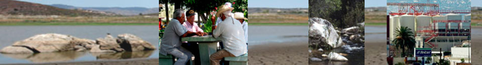
The Tijuana River Watershed (TRW) is a binational basin that lies across the U.S.-Mexican border. Some of the most pressing environmental and cultural issues identified in the literature include an explosive population growth, the water quantity needs of this population and flood control, water quality including heavy metals and sewage contamination; and the loss of important animal and plant species in this hotspot of biodiversity. Cultural issues include a decrease in quality of life and preservation of important Native American and archeological resources. See: EPA (2000), Delgadillo (2000), Ganster (1996), Gersberg (1996), IUCN (1997), Michel (2003), Wakida (1998), Wilkens (2001).
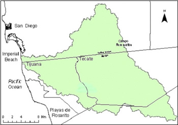
The watershed covers 1,750 square miles (4,465 square km) from the Laguna Mountains in the U.S. to the Sierra de Juárez Mountains in the south. The major tributaries are the Cottonwood Creek (U.S.), Pine Creek (U.S.) and the Río Las Palmas system (Mexico). This area is characterized by steep hilly terrain and a Mediterranean climate. Vegetation cover is dominated by chaparral and coastal sage scrub, along with wetlands (vernal pools and riparian zones) and conifers in the mountains. The temperature ranges between 8 and 18 degrees centigrade and precipitation ranges from 150 to 650 mm per year. See: Wakida (1998), Wright (1999).
Flooding
Problems resulting from the hilly topography and unplanned squatter settlements on slopes include erosion, flooding, and landslides. Intense precipitation resulted in severe floods in 1980, 1983, 1993, and 2008. These floods had devastating effects on natural habitat, structures, personal property, and transportation facilities in urban Tijuana and the Tijuana River Valley. It is anticipated that flooding will continue due to runoff from increased urbanization, lack of vegetation on hillsides to slow the flows, clogging of stream channels from sediment and debris, and an inadequate municipal storm drainage systems. In recent years improvements have been made through efforts by the City of Imperial Beach and the U.S. International Boundary and Water Commission to periodically clear the channel and other storm drainage systems in Tijuana of sediment and trash. See CNA (1995), CNA (2011), TRVRT (2012).
Water
Water is scarce in the watershed, with variable rainfall averaging only 250 mm (10 inches) per year. Imported water from the Colorado River serves much of the binational area and San Diego also imports water from Northern California through the California Water Project. See Ganster, Sweedler, and Clement (2001).
The Tijuana River discharges into the Tijuana River Estuary in the U.S. In this discharge, experts have measured high concentrations of suspended solids, Cd, Cu, Ni, Pb, Zn, and PCBs in Southern California. These heavy metals can bioaccumulate in people and animals, causing health problems. See SCCWRP (1992, 2012).
As water becomes more scarce and expensive, increased use of groundwater in the TRW may be considered. Contamination of aquifers from sewage runoff, fertilizers, and pesticide use causes concern for the health of well users. Illegal dumping of toxins by industries and businesses in Mexico is difficult to enforce. On the U.S. side, agriculture (the source of nitrogen, phosphorous, potassium, and pesticides) and industrial wastes also contribute to the contamination of the basin. The human health effects of these contaminants are an ongoing problem. See EPA (2000), TED (1997).
Biodiversity
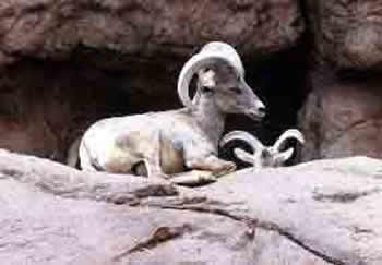
The flora and fauna of the California and Baja California are known internationally for their diversity and high levels of endemism (species found only in this region). The region contains many important endangered and threatened listed species such as Bighorn sheep and the Arroyo toad. The watershed also contains endangered vegetation communities such as coastal sage scrub and chaparral. Many of these plant and animal species are migratory and are known to exist on both sides of the border.
Loss of biodiversity in the TRW regions has been attributed to habitat fragmentation. The main human causes for habitat loss are cattle ranching, introduced exotic species that compete for resources, expanding urbanization, and human settlements into rural areas. Fragmentation of habitat can inhibit gene flow between populations of plants and animals, and cause population sinks that lead to extinction of a species. See Delgadillo (2000), Ney-Nifle (1999), Ojeda Reva (2000).
Climate Change
Numerous climate change models and the 2013 National Climate Assessment make it clear that the Southwest U.S. and the TRW will experience higher temperatures (1.5-2.0 degrees Fahrenheit minimum by 2021-2050). This will reduce the snowpack and stream flow that produce water imported to San Diego and Tijuana. Higher temperatures will pose increased threats to public health in dense urban settlements. Precipitation will be reduced, increasing wildfire risk to rural and periurban areas of the watershed. Finally, rising sea levels will increase coastal flooding and erosion, posing special challenges to the Tijuana Estuary ecosystem. The Tijuana River Valley Recovery Team is evaluating climate change impacts as well as mitigation and adaptation strategies for the Tijuana River Valley. See National Climate Assessment, 2013 draft, TRVRT (2012), Das et al. (2010), Zedler (2010).
References
American University Trade Environment Database (TED).1997. Tijuana River pollution.
Comisión Nacional del Agua (CNA). 1995. Programa Estatal Hidráulico, Gerencia Estatal en Baja California. Mexicali: CNA.
Comisión Nacional del Agua (CNA). 2011. Manual para el control de inundaciones. Mexico City: CNA
Das, T., M. D. Dettinger, et al. (2010). "“Potential impacts of global climate change on Tijuana River Watershed hydrology - An initial analysis.”
Delgadillo, J. (2000). Floristica y ecologia del norte de Baja California. Divulgare 29: 46-63.
Environmental Protection Agency (EPA). 2002. Cottonwood-Tijuana Watershed Profile.
Ganster, P. 1996. Environmental Issues of the California-Baja California Border Region. Border Environment Reports June(1): 1-14.
Ganster, Paul, Alan Sweedler, and Norris Clement. 2000. Development, Growth, and the Future of the Border Environment. In The U.S.-Mexican Border Environment: A Road Map to a Sustainable 2020. pp. 73103. Paul Ganster. ed. San Diego: San Diego State University Press. See about 200 vs 2001 citation
Gersberg, R. M. 1996. Monitoring and Modeling of Water Quality in the Tijuana River Watershed. Final Report SCERP Project WQ PP96II-10: 355-369.
IUCN. 1997. United Nations List of Protected Areas.
Michel, S. 2003. The U.S.-Mexican border environment : binational water management planning. San Diego, CA, San Diego State University Press.
National Climate Assessment and Development Advisory Committee (NCADC) National Climate Assessment, Chapter 20 Southwest, Draft 2013.
Ney-Nifle, M. M., Marc 1999. Habitat loss and changes in the species-area relationship. Conservation Biology 14(3): 893-898.
Ojeda Revah, Lina. 2000. Land Use and the Conservation of Natural Resources in the Tijuana River Basin. In Shared Space: The Mexico-United States Environmental Future. pp. 211-32. ed. Lawrence Herzog. San Diego, CA: UCSD Center for U.S. Mexican Studies.
Southern California Coastal Water Research Project (SCCWRP). 1992. Surface runoff to the Southern California bight: Annual Report 1990-91 and 1991-92. Westminster, Calif.
Southern California Coastal Water Research Project (SCCWRP). 2012. Southern California Coastal Water Research Project Annual Report 2012. Westminster, Calif.
Tijuana River Valley Recovery Team (TRVRT). 2012–. Recovery Strategy: Living with the Water. San Diego
Wakida, F. R., Karen. 1998. The Tijuana river basin: basic environmental and soicioeconomic data. San Diego, Institute for Regional Studies of the Californias: 104.
Wilkens, M. 2001. pers. comm. CUNA. Ensenada.
Wright, R. 1999 TWR. www.typhoon.sdsu.edu/tjwater/
Zedler, J. B. 2010. “How frequent storms affect wetland vegetation: A preview of climate-change impacts.” Frontiers Ecol. Envir. Frontiers in Ecology and the Environment 8(10): 540-547.