Human Characteristics
Population
In 2010, approximately 1.7 million people lived within the TRW (up from 1.4 million in 2000), and about 97% of this population reside within the Mexican portion of the watershed (INEGI 2004/2013; U.S. Census Bureau 2004/2013).
TRW estimated population (2010)—1,700,000
Mexico (municipalities of Tecate and Tijuana)—more than 1,660,762
United States (ten census tracts and the Campo Indian Reservation)—more than
58,800
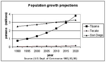
The Vision Research Team selected census tracks that fell within, or largely within, the watershed boundaries to calculate a population within the U.S. portion of the TRW as 43,963 in 2000 and 58,800 in 2010, which displays an increase of approximately 14,800 inhabitants in a decade (U.S. Census Bureau 2004/2013).
Tijuana is the fastest growing city in the watershed. In the decade 2000—2010, the population within
the Municipality of Tijuana grew from 1.2 million persons in 2000 to 1.6 million in 2010 (INEGI 2004/2013).
The population of the Municipality of Tecate grew from 77,796 persons in 2000 to 101,079 in 2010 (INEGI
2004/2013). Population growth in these border cities has
been mainly driven by migration from the interior
of Mexico.
The population of the watershed is expected to double from 2000 to 2030 (Peach and Williams 2003). Rapid urbanization and industrial growth in the San Diego, Tijuana, and Tecate area will continue to spread south and eastward.
As the population in the watershed expands, quality of life is likely to decline. Studies identified preservation of agricultural lands, indigenous lands, and open green space as important to residents of the watershed. See Ganster (1996).
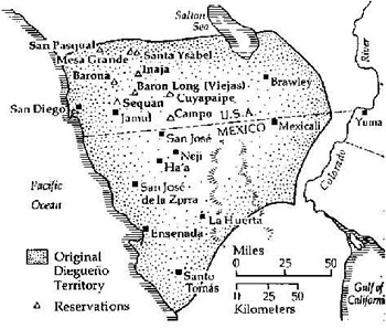
Native American tribal reservation lands in the U.S. portion of the watershed include Campo, La Posta, and parts of the Cuyapaipe and Manzanita. Traditional Kumiai presence in the Mexican portion of the watershed include lands at Juntas de Nejí and settlements at Peña Blanca, Tanamá, Valle de las Palmas, San José Tecate, and Aguaje de la Tuna.
Source: "Kumeyaay Lands 1769-2000" by Mike Connolly
Economics and Land Use

Economic growth in the region over the last 20 years has produced significant impacts on the watershed. The fast growing maquiladora industry imports components for further elaboration and re-export, and has attracted migrant workers from all over Mexico. See Wakida (1998). This trend of the maquiladora as a ‘pull’ factor of migrants to the Tijuana area was adversely affected by the 2008 financial crisis and the subsequent drop in the maquiladora industrial sector. The population growth rate for the region has slowed (based on INEGI 2013 data).
Experts project that 90% of the land within Tijuana will eventually be developed. Tecate’s industrial, commercial, and residential sectors are predicted to extend southward. San Diego’s population explosion is predicted to move southeast.
References
Instituto Nacional de Estadística e Geografía (INEGI). 2013. “Baja California.” Retrieved 15-Feb-2013
Ganster, P. 1996. Environmental issues of the California-Baja California border region. San Diego, CA, Institute for Regional Studies of the Californias, San Diego State University.
McGuiness, M. 2001. Predicting the Spatial Pattern of Urban Growth in San Diego County: An Application of the Clarke Urban Growth Model. Master thesis. Geography Dept, SDSU, San Diego.
Peach and Williams. 2000. “Population and Economic Dynamics on the US-Mexican Border: Past, Present, and Future.” In The US-Mexican Border Environment: A Road Map to a Sustainable 2020. Ed. Paul Ganster. Pgs 37-73. San Diego State University Press: San Diego, CA.
U.S. Census Bureau. 2013. Retrieved 4-Mar-2013
San Diego State University (SDSU) and Colegio de la Frontera North (COLEF) 2005. Tijuana River Watershed Atlas / Atlas de la Cuenca del Río Tijuana. San Diego, Calif.; [Tijuana], San Diego State University Press : Institute for Regional Studies of the Californias ; Colegio de la Frontera Norte.
Wakida, F. R., Karen 1998. The Tijuana river basin: basic environmental and soicioeconomic data. San Diego, Institute for Regional Studies of the Californias: 104.